LidarTools
A useful collection of tools to make it easier to work with Lidar files in BricsCAD®. The primary tool (LidarTin) creates a BricsCAD TinSurface directly from multiple LAS/LAZ files while allowing the use of classes like (2 = Ground) to filter out irrelevant points. A good collection of companion tools help in managing and pre-processing Lidar files.
- Create BricsCAD TinSurface objects from ground points in multiple LAS/LAZ files.
- Draw tiles representing the extents of selected files, including information labels.
- Create reports including point count, coordinate window and classification data.
- Create LAZ files from TinSurfaces in the drawing, using sampling methods.
Omschrijving
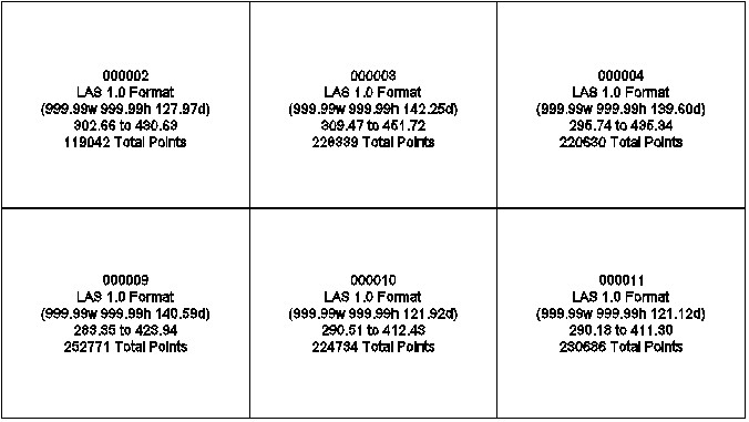
LIDARCONV Prompts for a selection of files then converts them to LAZ for maximum compression and compatibility with the tools below. For maximum speed and file integrity, this tool uses RapidLasso's LasZip for file conversions (with permission). LIDARLIST Creates a detailed report displayed in your default browser, ready to print. Includes point count, coordinate window, elevation min/max and optionally classifications and subcounts. LIDARMAKE Create a LAZ file from Tin/Grid surfaces (classification 2 for ground). Includes a surface sampler that writes out points on an virtual grid (user supplies interval) draped onto the surface for reducing existing overly dense surfaces. LIDARPLOT Plots selected lidar files as point objects in the drawing. Beware that AutoCAD tends to slow down significantly and/or become unresponsive or unstable with massive amounts of points. A separate session is highly recommended. LIDARTHIN Creates a reduced point copy of a dense file with various filters. Currently includes Interval (very useful for contours only) and optional elevation min/max removal. Echos percent reduction of each file at command prompt. LIDARTILES Prompts for a file selection of LAS/LAZ files, then draws rectangles in model space representing the extents of those tiles. Label information includes file name, min/max elevation and total number of points. Optionally include classifications found and the number of points for each. LIDARTIN Prompts for a file selection of LAS/LAZ files, which classes to use (separate multiples with a comma), then a rectangular window for your area of interest. Any points in a file that fall outside the window are not included. Any files selected that fall outside the AOI are not even scanned for points (saved time).

BricsCAD Pro V20 - V24
BricsCAD Platinum v20, BricsCAD Pro v21-v24, Windows Only
Windows
Dotsoft
3390 Morehead Rd
FlemingsburgKentucky410418077
UNITED STATES
(606) 849-4312