Plex-Earth Lite
The FREE plugin to bring Google Maps imagery into BricsCAD!
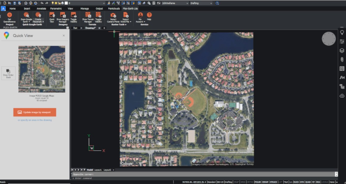
- QuickViews: Get a snapshot of your project area using high-quality imagery from Google Maps
- Georeference drawings using 4,000+ systems, coordinates, or Google Earth placemarks
- Import single elements with a simple copy-paste from Google Earth
- Creates placemarks, paths and polygons directly from within your drawing
- Raster tools: export/import images based on World Files, geo-tagged photos from your camera etc.
Description
GOOGLE MAPS IMAGERY - ESSENTIAL GOOGLE EARTH TOOLS & MORE - FOREVER FREE ——————————————————————————————————————————————————— Plex-Earth Lite brings Google Maps and essential Google Earth tools into AutoCAD — Free, Fast, and Easy. View your site with up-to-date satellite imagery, georeference your project in seconds, import geotagged photos, and digitize Google Earth objects directly in your drawing. All inside BricsCAD. All for Free. —————— BENEFITS —————— - Instantly visualize your project in its real-world setting - Georeference any drawing easily — no GIS expertise required - Share early designs with clarity and confidence - Perfect for feasibility studies, concept design, and site exploration - Lightweight, frictionless setup — no license manager ——————————————— FEATURES AT A GLANCE ——————————————— - QuickViews (Google Maps): Get a snapshot of your project area using high-quality imagery from Google Maps. - Easy Georeferencing: Automatically align your drawing using location data or choose from 4,000+ global coordinate systems. - Points of Interest (POIs): Mark and manage key locations to streamline exploration and site understanding. - Google Earth Tools: Create Placemarks, Paths, and Polygons by digitizing directly in AutoCAD — ready to view in Google Earth. - Import Geotagged Photos: Bring real-world context into your drawing by importing photos taken with GPS-enabled smartphones or drones. - WorldFile Support (Import & Export): Import images using accompanying WorldFiles (.jgw, .pgw, etc.) or export your own images with WorldFile metadata for GIS alignment. - Plans & Licensing: Plex-Earth Lite is completely free — no activation, no expiration. Need more power? Upgrade anytime to Plex-Earth Pro for advanced functionality, including high-resolution mosaics, terrain models, historical imagery, and premium providers like Airbus, Maxar, Nearmap and Hexagon. — Empowering thousands of engineers since 2009 across civil, solar, telecom, infrastructure, and more. Design with real-world insight — from concept to construction.

BricsCAD Ultimate V21 - V25
Windows
Plex-Earth Lite 26.1.9236
BricsCAD Pro V21 - V25
Windows