SPCAD
SPCAD for BricsCAD is a powerful plugin for BricsCAD users needing terrain analysis tools for 3D planning. It is ideal for cartographers who need to create multiple maps quickly, urban and town developers, and land revenue offices to develop and manage cadasters. Additionally, it serves geospatial experts by enabling the import and export of geospatial formats to and from DWG files, performing geometry-based analysis while maintaining coordinate systems and measurement units.
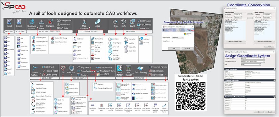
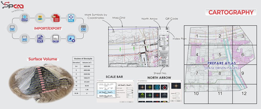
- Import and export all popular geospatial data formats to and from DWG.
- Coordinate Transformation and Geo-referencing of DWG files.
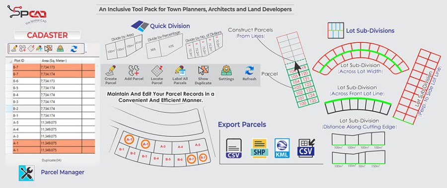
- Lot Subdivion, Parcel Management and Annotation of Cadastral Maps.
- Creating Map Atlas with cartographic standards and specifications.
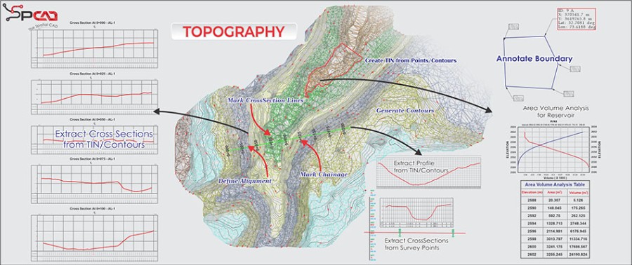
- Topographic Surfaces, Cross Sections, Profiles and Volumetric Calculations.
Description
SPCAD is a powerful plugin for BricsCAD, available in both Spanish and English, designed to enhance the geospatial capabilities of BricsCAD versions 23 and 24. This comprehensive toolset streamlines CAD workflows and boosts productivity by offering a wide range of functionalities. With SPCAD, you can effortlessly import and export various file formats such as KML, Shapefile, CSV, and GPX, ensuring smooth data integration and sharing. It also allows users to easily manage coordinate systems in their drawings, assign or unassign systems, display system information, and convert coordinate values for different projections. Additionally, importing Bing imagery directly into DWG files enhances accuracy and context. SPCAD's Cartography panel empowers users to enhance their drawings with elements like North Arrows, Scale bars, and Legends, while allowing for the categorical placement of symbols and creation of Data-Driven sheets for linear features and areas. For topographic analysis, SPCAD offers robust tools, including the ability to define alignments, create TIN surfaces, contour lines, and elevate points on TIN. Users can also generate longitudinal profiles and perform complex tasks such as cutting cross-sections and labeling contours, with support for importing DEM files in .tiff format. The Analytical Panel enables users to cut and merge closed polylines, create buffers, and generate lines or polygons from point objects, providing advanced tools for precise analysis. Geometry-related tasks are expedited with features that allow for the creation of right-angled triangles, rectangles, and angle bisectors, along with the conversion of 2D to 3D polylines and reduction of polyline nodes. The Cadaster panel simplifies parcel management through its Parcel Manager, facilitating the creation, addition, location, labeling, and organization of parcels, along with lot subdivision methods and parcel creation from polylines. The SPCAD panel provides access to essential features such as Online Help, Language Switching, License Manager, Updates, and About, offering comprehensive support and customization options. SPCAD for BricsCAD is an indispensable tool for professionals aiming to enhance their design and mapping capabilities with advanced geospatial functionalities.

BricsCAD Pro V22 - V24
64 Bit Windows 10
Windows
Cadomation Private Limited
453-Rahman Center, 2nd floor, Ravi Block, Allama Iqbal Town
Lahore54000
PAKISTAN
www.cadomation.com
+924235468982