Geo-Plus VisionCivil Pro
This civil engineering design and documentation software allow professionals to improve workflow and deliver faster to their customers. VisionCivil allow the creation and edition of TIN surfaces, profiles, cross section plans, capping, pipe services. Its platform also calculates accurate volumes, produces detailed reports and way more. Furthermore, we have combined all the powerful features of VisionCivil with our LiDAR software. The combination of these 2 softwares, makes your work significantly simpler.
- Powerful and flexible TIN manager with different volumes calculations for all kind of projects
- LiDAR module to create surfaces from your point clouds
- Powerful parcel manager with building siting automatisation, metes and bound or closure reports, etc
- Effective string and connectivity manager from field data to create surface with breaklines
- Combined scale factor for all objects
Description
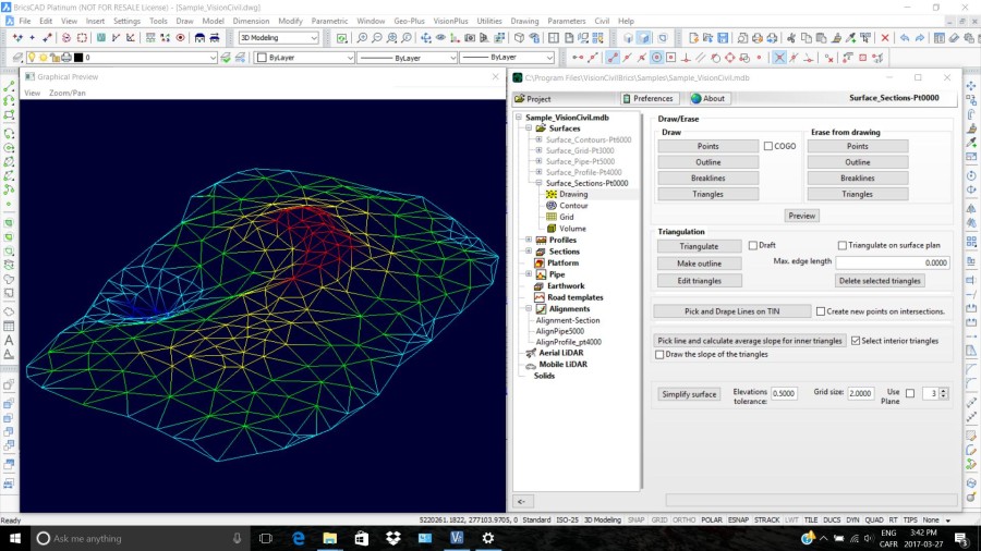
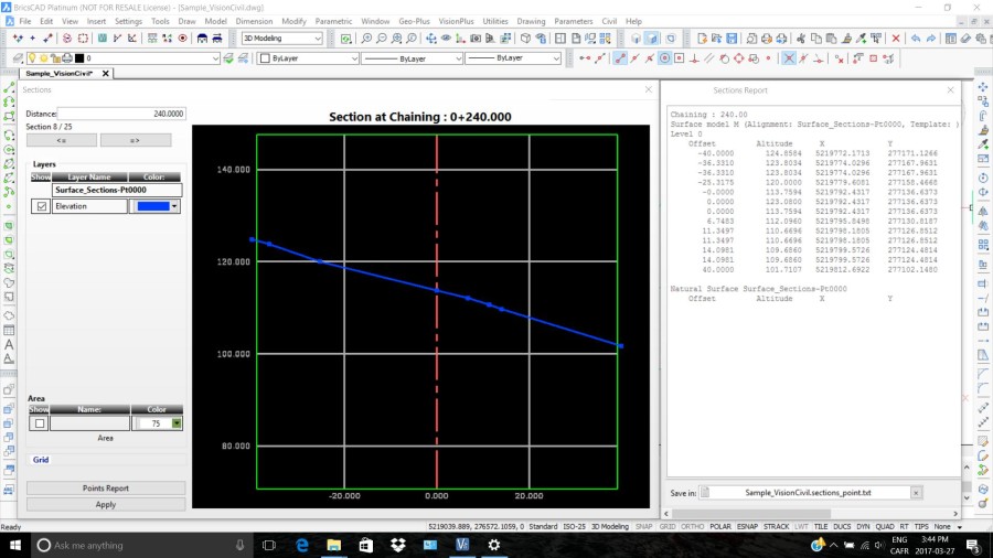
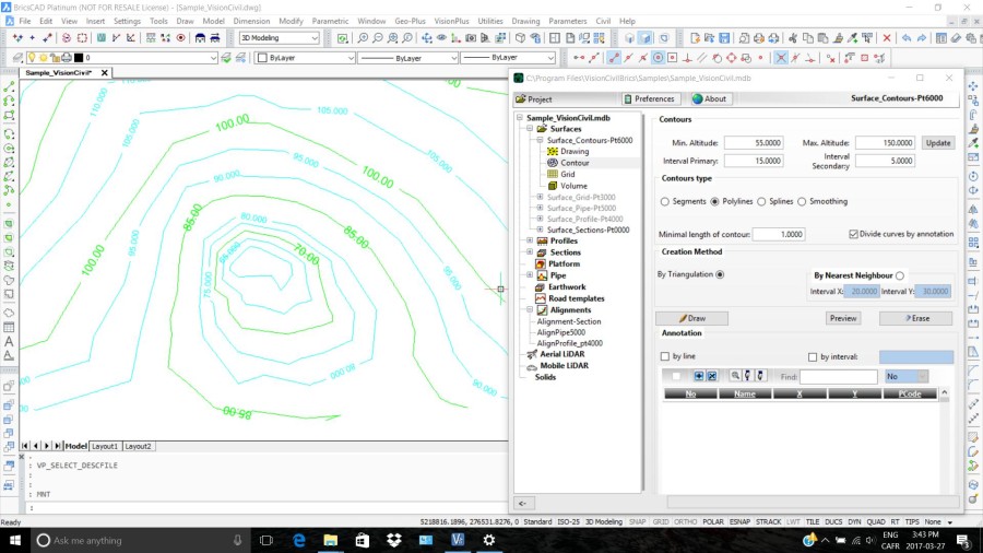
VisionCivil Pro integrates into your favorite CAD tool such as BricsCad® to improve its functionality and usability. VisionCivil Pro can also be the bridge between them.VisionCivil Pro uses an external CAD database. This way, the drawing is lighter for the workstation to handle. Sharing your data becomes easier! You can easily triangulate a surface created from graphics selections or point groups, edit your surfaces easily by adding breaklines and holes. Use powerful COGO features, work with 2D and 3D profile alignments, and customize your profiles and sections. Precisely calculate volume between two surfaces, sections or complex volumes (overhangs). Apply a combined scale factor to all objects and easily handle LiDAR point clouds. Create drawings according to your own standards or those of your customers or subcontractors. Improve project delivery time with time saving land survey and civil engineering features and respond faster to your customer’s needs and much more! Benefits Multiplatform VisionCivil Pro can be installed on AutoCAD®, MicroStation® or BricsCAD® within the same organization so the learning curve is minimal. Sharing data and standards between different departments or with different subcontractors is now easy and time saving. External Database Having an external database to store points, linework, parcels, surfaces and others has many advantages. First, it lightens the drawing file. Second, it accelerates processes. Third, the data can be shared more easily and transferred from one CAD to another at the blink of an eye. Lastly, since the same database can be use with our many software solutions, it allows you to have the right software for the right person at the right cost. Interaction All of our software solutions interact with one another. VisionCivil Pro shares the same databases with VisionPlus, VisionCivil Lt and VisionLiDAR. Cartridge information can be filled automatically by VisionDoc. Information can also be pushed to or updated from VisionCarto and VisionPad as well. The more Vision software you have the easier your work gets. Multi-user With an external database stored on the server, multiple users can work on the same project simultaneously. For instance, the field team can drop their data while the draftsman is currently working on one of the final plan and the surveyor is currently adjusting the old survey to the correct coordinates. Another person could also simultaneously do virtual surveying in VisionLiDAR to create linework for the draftsman to incorporate. Customized Standards You have your own drawing standards and you want to keep them? No problem! All the tools are implemented for you to configure your own or select already created ones. In fact you can easily change from one standard to another allowing you to use the same data for two different ends, by converting the standards and PCodes of a project. Keep a standard for all your contractors and always deliver the right product. Features: Complex Volumes We offer you four methods to calculate volumes: surface to surface, grid to grid, cross sections and solids. This allows you to better verify your results and add precision to your proofs. You can see the cut and fills planimetrically with the surface to surface method to better judge your project. The solid method allows you to calculate overhangs and complex solids and holes that would not be possible with standard volume calculations. LiDAR Import large aerial and terrestrial point clouds. Extract only the class and regions you need to generate surfaces by simplifying the point cloud and only keep the important points that will reflect surface behaviors. You can then easily analyze a project ‘before and after’ with your data and use your LiDAR files for other projects. Building Siting Place, move and rotate your building footprint inside a parcel with ease, respect the chosen constraints and automatically get all the needed quotes. Drawing the staking box is just a few clicks away! Parcel Management Our powerful parcel manager allows you to automatically create parcels from survey points or from existing drafts. It analyses parcel topology, inscribes only the needed measurements and validates fixed measures to spot drawing flaws. You can also easily generate legal descriptions, metes and bounds or parcel closure reports with a selected template. Surface Management Creating, editing and triangulating surfaces can be as fast and easy or as complex and meticulous as you need. Just select the points and breaklines you need and triangulate them to automatically create your boundaries. You can also invert triangles, create holes, simplify your points, carve boundaries, add different material layers, and much more! Profiles and Cross Sections Personalize your profiles and cross sections for the office and easily generate graphs for your surfaces within the CAD with all the desired information. Show the vertical curves, the different layers and slope materials exactly the way you want. Pad design Easily calculate cut and fill of pads and retention basin by drawing their contours with lines or arcs to compare them to the surface. You can adjust the slope for each segment to reach the desired surface and automatically generate a new surface. Earthworks Build road templates and create a theoretical road over a surface to calculate the fill and cut of every material contained in a surface. You can also compare with an “as build” surface and see the payable volume. Field Book Import/Export We offer you many functions to control and manage your data collectors. Import, export, adjust traverse, validate, exclude, correct observations, automatically draw the survey and manage the linework with your desired standards, etc. All manipulations are written in the final reports to allow a constant data control. Powerful COGO The included COGO module brings all the needed mathematical functions for your works. You can easily calculate and implement traverses, inverse, intersections, curves, find the best line, best curve, translate/rotate by least square and many more. All of them will be automatically inscribed in your final report. Points and Notes Points and notes are associated with PCodes to allow different symbols for different entities. This feature helps to create a faster and more precise drawing directly from field data. If specified, the notes are transferred in the database and drawn. Get a quick field notes review without overloading the drawing! Linework Simply bring your linework from the field to the drawing with our powerful chain manager. The PCodes and line codes will then automatically be recognized to draw the linework with your standards. The chain manager can change a PCode, the point order or the direction of a line. You can also detect crossings and create surfaces very easily! Combined Scale Factor Work with large projects easily! VisionCivil Pro functions are adjusted with your desired combined scale factor. The combined scale factor can be specified or calculated from known points. All your drawings will then reflect the field without any headaches!
Documentation


BricsCAD Pro V20 - V22
Windows 10, 64 bits
Windows
1.800.672.1733