Plateia - Software for Road Design
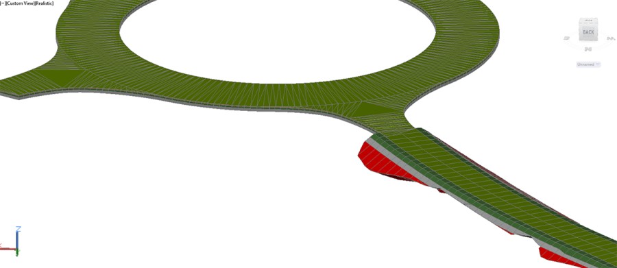
Plateia is a professional, BIM-ready, 3D road design and reconstruction software solution. It provides the commands and tools to support the entire design process, from preliminary to detailed design, from the initial input of survey data to complex 3D road models with analysis tools, to documentation and publishing features.
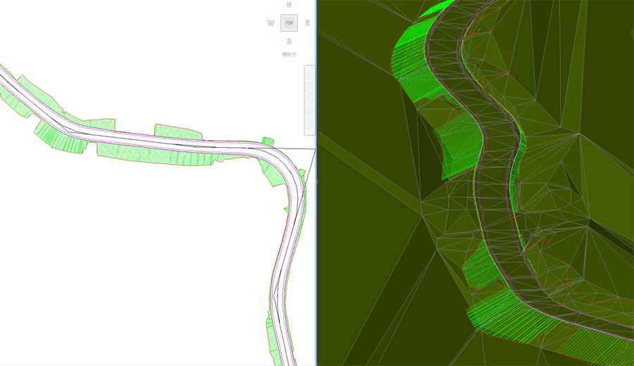
- Layout module for processing input data and drafting in plan view.
- Axes module for manipulating horizontal alignments.
- Longitudinal sections module for processing profiles of roads.
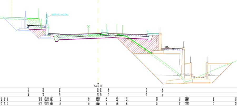
- Cross sections module for designing and processing of cross sections.
- Traffic module provides advanced tools for Traffic Signalization, Intersection Design and Swept Path Analysis.
Description
Using its flexible, dynamic data model, Plateia supports BIM (Building Information Modeling) workflows and processes. Carefully designed UI and workflows are consistent with the road design engineering practice. This makes Plateia fast-to-learn and easy-to-use. See more >> http://www.cgs-labs.com/Software/Plateia.aspx *** DESIGN FEATURES *** 1. Digital Terrain Modeling The Surface creation tool is included in CGS plus software to produce detailed Digital Terrain Model (DTM) based on various surveys or other input data: total station data files, points, break lines, blocks, etc. This offers the possibility to use Plateia on plain AutoCAD or BricsCAD. 2. Grading Creation of complex slopes with multiple conditions in cut or fill gives users the capability to cover various design scenarios and geometry requirements for all kind of road projects, from simple forest road design to complex intersection geometry design. Furthermore, creating ponds, parking areas, platforms, road, rail tracks, river channels, and other features is easier and faster with CGS plus grading functionality. 3. Roadway Geometry Design Tools Plateia provides a wide range of advanced alignment, profile geometry design, and editing tools. They include P(V)I design, floating and fixed elements design, alignment design created from the existing polyline, or ultimately creating a best-fit alignment based on existing road centerline or road edge survey data. Superelevation calculation is a comprehensive definition and editing tool. Plateia supports several superelevations definitions and pivot point options according to various European and AASHTO roadway design standards. A number of alignment labels according to different country standards, reports, and data export options give you the flexibility to cover a wide range of user requirements. 4. Intersections and Roundabouts Automated intersection and roundabout design is based on road geometry defined by alignment, profile, and super-elevations. The 3D Intersections function automatically adjusts secondary road profile and super elevation parameters with corresponding user defined curb returns. Automated intersection design results in detailed 3D intersection geometry for X or T shaped intersection types. Use the grading/surface mode with various parameters to customize 3D intersection geometry, and then use the automatic update option when alignment geometry changes. 5. 3D Surface and 3D Solid Model Roadway 3D model can be created as 3D surface or 3D solid model. 3D roadway surface model can be generated automatically from 3D road edges and terrain model, or it can be built with the grading function. 3D solid model is created on the basis of cross-section areas, where materials and volumes can be defined as extended data. With 3D solids we can also build tunnels, bridges and similar objects. Solid objects can be aligned with arcs and transition curves. All solid models, including extended data, can be imported into Autodesk Infraworks, Navisworks and can be used in various BIM workflows. 6. Cross Section Design and Editing Capabilities Plateia provides capabilities for designing and editing roadway cross sections in a detailed way with almost no geometry limitations to the final project design. Adding multiple roadways to a single cross section gives you control over the geometry between the roads and other infrastructure objects your project requires, and lets you define these areas with great accuracy and detail. 7. Quantity take-off (QTO) Plateia calculates material quantity take-off and features a QTO data export tool with custom defined Pay Item (Bill of materials) options. It gives users the possibility to link material defined in the drawing with a material database in cost estimate software, thus supporting digital data transfer and fast cost recalculation when project changes arise. 8. Mass Haul Diagram Mass haul diagram presents a graphical view of the material moved in the proposed design site. Mass haul diagrams help designers and contractors understand where gross material movements occur and compare the economies of alternative designs. These diagrams are presented along with profile views for the design review phase. 9. Road Reconstruction/Rehabilitation The road reconstruction/rehabilitation function offers powerful regression analysis tools for best-fit alignment and profile creation based on existing road centerline or road edge surveyed data. This gives you a detailed profile view for the existing and new roadway elevation, together with a calculation of resurfacing material quantities. 10. Autosign: 3D Traffic Signs, Road Markings, and Road Sign Gantry Autosign is included in Plateia Ultimate 4D and Plateia Professional 3D software suites. It provides users with everything necessary to design, edit and visualize 3D traffic signs, road markings and road sign gantries. Several country-specific traffic signs libraries are available as well as traffic signs and road markings reports with quantity data. See more >> http://www.cgs-labs.com/Software/Plateia.aspx
Documentation


BricsCAD Pro V22 - V25
Windows
CGS Labs d.o.o.
Brnciceva ulica 13
Ljubljana-Crnuce1231
SLOVENIA
+386 1 235 06 00