AQUATERRA - Channel and River Works design
Aquaterra is a professional CAD/BIM software for channel and river engineering design. It integrates MIKE FLOOD or HEC-RAS hydraulic calculations with flood protection design, torrent and landslide control, and irrigation systems design.
- Layout module for processing input data and drafting in plan view.
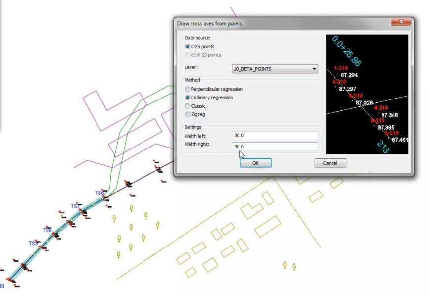
- Axes module offers powerful commands for manipulating longitudinal and cross axes.
- Longitudinal Sections module contains the commands for processing profiles of rivers and canals.
- Cross Sections module contains the tools needed for designing and processing sections.
- Support for industry-standard hydrodynamic simulation systems: HEC-RS, MIKE 11, MIKE FLOOD, MIKE21
Description
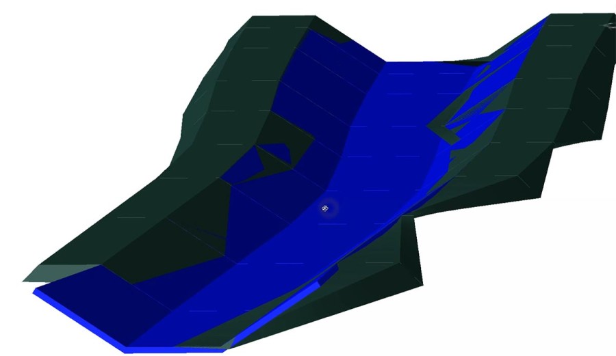
Integrated Design for Flood Management Projects AQUATERRA seamlessly integrates specialized CAD/BIM tools with advanced hydraulic calculation and simulation solutions, such as MIKE+ and HEC-RAS. It is designed for a variety of hydrologic projects, including channel and river engineering design, flood protection measures, and irrigation systems. Comprehensive Project Design AQUATERRA supports every stage of project development, from conceptual studies to detailed design. Starting with the river axis, longitudinal, and cross-sections data, users can efficiently construct a 3D solid model of the riverbed and banks. This enables accurate quantity calculations and the preparation of comprehensive printed documentation. BIM Workflow and IFC Compatibility AQUATERRA fully supports BIM workflows, enhancing collaboration and project management. By utilizing the IFC standardized data format, AQUATERRA ensures compatibility and seamless data exchange with other software platforms. See more >> http://www.cgs-labs.com/Software/Aquaterra.aspx Essential Tools for River Engineering 1) Digital Terrain Modeling Use AQUATERRA to create Digital Terrain Models (DTM) from points, break lines, and blocks or use an external reference drawing. AutoCAD and BricsCAD surfaces are supported as well. 2) Grading AQUATERRA enables the creation of complex slopes with multiple conditions in cut or fill, giving users the flexibility to address a wide range of design scenarios and geometry requirements for all types of river projects. 3) River Alignment Design Tools Create an alignment using the tangent polygon, create alignments from existing polylines or generate best-fit alignments based on existing channel or riverbed survey data. 4) Cross Sections Design and Editing Capabilities Insert 1D water level calculations from MIKE or HEC-RAS hydraulic analysis, edit an existing channel cross-section geometry and then recalculate water levels in the hydraulic simulation software to assess the impact of geometry changes. 5) Water Level Representation and Smart Lines Definition Insert water level lines in the waterway profile and cross-section views based on data from hydraulic calculation software such as MIKE+ or HEC-RAS. Accurately depict side objects like channels, dykes, and property limits, by defining projection lines along the axis in the layout and project them into profile or cross-section views and vice versa. 6) Quantity Take-off (QTO) Create a material quantity take-off table from the planimetry polygons and export the table in a custom format. 7) 3D Solid Model Automatically create BIM model from the planimetry polygons. Easily attach property sets and export it to the IFC standardized format. 8) Support for MIKE+ MIKE+ by DHI is a powerful flood modeling solution for simulating various flood scenarios, including rivers, floodplains, and urban drainage. Seamlesly transfer river geometry to MIKE+ for hydraulic calculations and import the results back into AQUATERRA to show water surface in profile and cross-section views. 9) Support for HEC-RAS HEC-RAS is a widely used software for hydraulic calculations. AQUATERRA’s integrated interface allows easy transfer of channel or river geometry between the CAD environment and HEC-RAS for water flow analysis. 10) Support for BIM and IFC AQUATERRA supports comprehensive BIM data, creating 3D models with detailed metadata for river engineering and other hydrologic projects. Models and attributes can be exported to IFC files, regularly updated per buildingSMART standards. 11) Google Maps & Google Street View The Google Maps Import feature allows for easy import of raster images and elevation data of a selected location directly into a DWG drawing, using the chosen coordinate system.
Documentation


BricsCAD Pro V22 - V25
Windows
CGS Labs d.o.o.
Brnciceva ulica 13
Ljubljana-Crnuce1231
SLOVENIA
+386 1 235 06 00